Example of a Mountain Pass Landform:
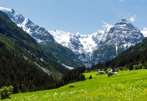
Col de l’Iseran, Alps Mountains, France
The mountain pass picture above is of the Stelvio Pass in Italy.
A mountain pass is the highest portion of a path through a mountain range.The highest portion of the route is also the lowest route that can be traveled between mountains on each side.
A mountain pass may be formed naturally between 2 volcanic peaks. Glacier activity, rain and running water from snow melt may also help to form a mountain pass.
A pass through a notch in a mountain ridge can be very narrow, as little as 20 feet. A pass through a large mountain range can be much larger, in the form of a valley between two peaks.
One or more mountain passes can be found on a road that passes through a mountain range. Two valleys on each side of a line of mountains are sometimes connected by a mountain pass that permits travel from one to the other. A mountain pass can usually be found in a mountain range that divides two countries.
• Col de l’Iseran, Alps Mountains, France
• Independence Pass, Rocky Mountains, Colorado, USA
• Argentine Pass, Rocky Mountains, Colorado, USA
• Ticlio-Pass, Andes Mountains, Peru
• Simo La, Tibet, China
The highest paved mountain pass in the European Alps is the Col de l’Iseran in France near the border of Italy at an elevation of 9,088 feet. It allows passage to popular ski resorts north of the pass. Independence Pass is located near Aspen, Colorado on the Continental Divide and may be the highest paved mountain pass in the US. The route is known for spectacular views, crossing at an elevation of 12,095 feet.
Argentine Pass of central Colorado can be crossed with a four wheel drive vehicle or mountain bike when conditions are good. It is one of the highest passes for a vehicle in the US at 13,205 feet, located in the Front Range as part of the Rocky Mountains. Ticlio-Pass, also known as Abra Anticona, is found east of Lima, Peru in the Andes Mountains and is the highest confirmed paved mountain pass in South America at 15,808 feet.
Semo La of Tibet (“La” means pass in the Tibetan language), at an elevation of 18,258 feet, may be the highest confirmed mountain pass in the world on which vehicles can travel. Marsimik La may be higher than Semo La, and has a rough road that may be passable by four wheel drive vehicles and off-road bikes.
However, reports for the altitude of Marsimik La don’t agree, so it’s difficult to confirm. There are also reports of higher passes with rough roads in other remote regions in the Himalayas of China.
The highest point of a route through a mountain range
We want pictures and location of the lanforms around the world and we need your help. Click get started button below.

In Asia, China, India, Nepal, and Bhutan are home to one of the eight wonders of the world and one of the most beautiful mountains in the world, the Himalaya Mountains also called the Himalayas. Boasting as the world’s highest and most famous mountain peak, Mt. Everest. Within the verse of the ‘Kumarsambhava’, Sanskrit […]

Nature have provided us with fascinating landforms and features. The most often adored landforms are volcanoes. Like the perfect cone structure of Mayon Volcano in the Philippines or Mount Fiji in Japan, people look at their beauty and wonder with great appreciation to nature. Volcanoes are mountains with a very disastrous nature. Their only […]

Taal Volcano is the second most active volcano found in the province of Batangas. A complex volcano in the middle of Taal Lake and is often called an island within a lake, that is an island within a lake that is on an island as well as one of the lowest volcano in the […]

Mayon Volcano is one of the active volcanoes in the Philippines. Located in the southern part of Luzon about 473 kilometers (294 miles) from Makati Business District of the Philippines, Mount Mayon is the main landmark of the Province of Albay of Bicol Region. According to local folklore, the volcano was named after Daragang […]

The global temperature and weather is to a large extent a direct result of the sun’s effect to our planet. Together with the atmosphere and the rotation of the earth on its axis. The earth on which weather moves on has its own effect on the weather. The different landforms like mountains, volcanoes, plains, and the […]

