2015
New Maricopa Trail re-routes were done on the west part, north of Wind Cave TH. Although there are a few significant changes, the mileage is almost identical.
Overview
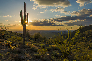
Pass Mountain Trail is a great loop trail in the Northeast Valley. Located in the Usery Mountain Park, there are trailheads both inside the Maricopa County Park and outside the park boundary. The majority of the trail runs through Tonto National Forest.
remove free decal offer
There are three access points for this trail. One is from the horse staging/ picnic area at the east end of the park. This is the actual trailhead with the trailhead sign indicating the trail name and distance. The second is from the Wind Cave Trailhead. The third is not inside the park (I start at this one) but rather on National Forest land at Meridian Road's Northern terminus. If you are looking for a longer hike, you can access Pass Mountain Trail from the Coleman and Blevins trails.
Hike
This trail description will start from the Wind Cave trailhead inside the park. It would be a better start for 1st-time visitors to this trail, out of towner's, relatives, etc. There are restrooms available as well as Ramadas and tables. There used to be Pepsi machines, but they have not returned since the bathrooms were redone. This is also the most populated trailhead as the Wind Cave is why most people come to Usery.
About 100 feet past the Wind Cave Trailhead, you'll come across signage indicating Pass Mountain Trail. Turn Right. This description reports the loop counter-clockwise. I have done the hike in both directions and prefer this option.
For the next 2 miles or so, you will be weaving through washes along the southern slope of Pass Mountain. You'll pass Cat Peak on your right (South), which offers a side trip if interested. You'll see private homes on your right at about the 2-mile mark. Just up the trail, you'll head North.
If you make a navigational error, you will do so here. The Meridian Trailhead is about a quarter-mile to the East along the fence line. In between is a steep-walled canyon. There are quite a few spur trails in the area. If you maintain a bearing of North, you will do fine. Don't head east, or you are off on another adventure. As a rule of thumb, if you descend into the canyon, you went the wrong way.
Stay on the Pass Mountain Trail heading north. Eventually, you will begin to turn toward the West (left). You'll be able to see the Pass that you are heading toward. Make sure to stop and look behind you, as the views of the cliff face of the Superstitions are fantastic. You have been walking for about 3.4 miles when you pass between two large boulders. You can see the trail as it snakes up the side of the mountain to the pass.
At the 3.5-mile mark, you'll begin heading to the right as you traverse the side of the mountain. A great picture spot is where the trail turns left around a shoulder. You can't miss it, wide trail, beautiful spot.
Between this spot and the pass, the terrain alternates between loose rocky ground and firm slick rock. This area can be very slippery in wet conditions. As you head back toward the East under the cliff, the trail ascends at a steeper angle. The drop off to the left is more pronounced... be careful.
At 3.9 miles, you reach the Pass. Great spot for a break. Excellent views. Lovely flat, wide-open area. You'll be looking at the backside of the Pass Mountains. The Salt River and the large cliffs along it are visible, as is Four Peaks and the Rim. On a clear day, this view is spectacular. I once watched a storm roll in from a protected area here, just beautiful. There is a side trail that heads up to the right (East). It leads to a cave and even better views. Scrambling up the ridge is also possible. You could spend some time exploring this area. Your elevation is 2,588 feet.
Continuing, you'll be heading toward the West. The trail gradually descends. You will be crossing a few washes/draws as you hike along the mountains' northeastern slope. At 4.3 miles, you'll pass two conglomerate boulders. This portion of the trail is easy to follow. Enjoy the views. As you approach the Western edge of the mountains, you may begin to hear gunfire. Your ears are not deceiving you. The firing range below the PHOENIX sign on Usery Mountain is not far away. Nothing improves the solitude of a desert hike like the sound of semi-automatic gunfire.
At 5.8 miles, you will pass through the fence back into the Recreation Area. This is the "long" section. From this point to the trailhead, you go through countless washes as you hike below Pass Mountain's western slopes. There are a few big ups, but nothing that I would call strenuous. This area is classic desert hiking.
At 7.4 miles, you return to your starting point. If you're still thirsty for more hiking, head up the Wind Cave Trail.
This is a great hike close to home. The trail is rarely crowded. I have seen more wildlife on this trail than any other in the valley. I encountered two deer, one huge desert turtle, an army of red ants, three coyotes, and a tarantula on a recent outing. I have seen more rattlesnakes on this hike than any other, so take care. I most enjoy this hike if I can time it to be finishing up around dusk. As for times, well, they can vary. We took my wife's aunt and uncle from Illinois on this hike, and at a slow to moderate pace we went just over 5 hours. I've done it myself in less than 3 hours.
A short option to the whole 7.4 miles would be to start at the Meridian Trailhead and do an out and back to the Pass. I like that as an after-work hike.
WARNING! Hiking and outdoor related sports can be dangerous. Be responsible and prepare for the trip. Study the area you are entering and plan accordingly. Dress for the current and unexpected weather changes. Take plenty of water. Never go alone. Make an itinerary with your plan(s), route(s), destination(s) and expected return time. Give your itinerary to trusted family and/or friends.
To Usery Wind Cave Trailhead Directions to Usery Park: From the west on the 202 (Red Mountain Freeway) continue on PAST the FIRST McKellips exit ~10 mi, past Power Rd and take the SECOND McKellips exit. At the top continue on to your left around the round-about over the 202 and continue east on McKellips Rd. About 3 miles east of the 202 you come to Ellsworth Rd. Turn LEFT on Ellsworth and go north about 2 miles, turning right into Usery Mountain Regional Park just past the sign.
From the south on the 202, take the McKellips exit and head east, continuing to Ellsworth as above.
From the west on US 60 take the Ellsworth exit and head north on Ellsworth which eventually becomes Usery Pass Road north of McKellips. Continue past McKellips about 2 miles, turning right into Usery Mountain Regional Park just past the sign.
Directions to the Wind Cave trail head: Once in the park, continue on past the new (Spring 2010) Nature Center building to the information/entrance building where you either purchase a one-day pass or purchase an annual pass (good in all Maricopa Parks except Lake Pleasant) for seniors. If it's your first visit, be sure to ask for a map including information of the all 29 miles of trails in the park. After setting your pass receipt on your dash, continue on the road as it curves around toward the east. Continue past the four-way intersection until Wind Cave Drive on your left. Turn up the drive and follow it until you find a suitable parking place. If it's busy just continue on around the one-way loop until you find an empty spot along the road. The trail head itself is immediately to your right when looking at the Wind Cave facilities building.
Alternate Longer Access: For $2 per-person access turn right (east) off Ellsworth Road at McKellips road and drive about a mile until it ends at Crismon Rd. There is a parking on the SW corner. Entrance to the park is on the NE corner, there are maps and a payment box. The trail that heads north is loose and hard to walk, go east 1/2 mile to trail then head north 1 mile to horse staging area. Starting from this point adds about 5 miles to your round-trip hike to the Wind Cave Trailhead. Also about 150 feet in gain.
From PHX (I-10 & AZ-51) 34.8 mi - about 43 mins (up to 1 hour 10 mins in traffic) From TUC (Jct 1-10 & Grant) 128 mi - about 2 hours 0 mins From FLG (Jct I-17 & I-40) 173 mi - about 2 hours 45 mins
 Route Editor