
Alaska’s towering mountains are part of what makes the state so beautiful. That also means Alaska’s highways sometimes have to cross some formidable terrain. This list of the ten highest highway passes in Alaska doesn’t include all of the high-elevation passes covered in the MILEPOST. For instance, Chilkat Pass, elevation 3,510 feet/1,070 meters, is on the Haines Highway just across the border in British Columbia. Summit Pass is the highest summit on the Alaska Highway with an elevation of 4,250 feet/1,295 meters, near Summit Lake, British Columbia.
Mentasta Summit
Elevation 2,434 feet at Milepost GJ 79.2 Glenn Highway.
The Mentasta Mountains rise to about 6,000 feet on either side of the highway here.
Thompson Pass
Elevation 2,678 feet at Milepost V 25.9 Richardson Highway.
Snow poles along the highway mark the edge of the road so snow plows can make their way through this area notorious for its extreme snowfall. Record snowfall in Thompson Pass is 974.5 inches for a season, 298 inches for a month, and 62 inches for a 24-hour period.
Tahneta Pass
Elvation 3,000 feet at Milepost A 122 Glenn Highway.
Tahneta and Leila lakes are in close proximity to the summit. Tahneta has good spring fishing according to the Alaska Department of Fish and Game and Leila has abundant 8- to 14-inch arctic grayling.
Twelvemile Summit
Elevation 3,190 feet at Milepost F 85.5 Steese Highway.
Reach the summit by taking a half-mile access road to sweeping views. The summit is the divide of the Yukon and Tanana river drainages.
Isabel Pass
Elevation 3,280 feet at Milepost V 197.7 Richardson Highway.
A gravel parking area to the east offers views of Gulkana Glacier. The parking area also has an informational sign about women in the gold rush, including Isabelle Barnette, for whom the pass was named.
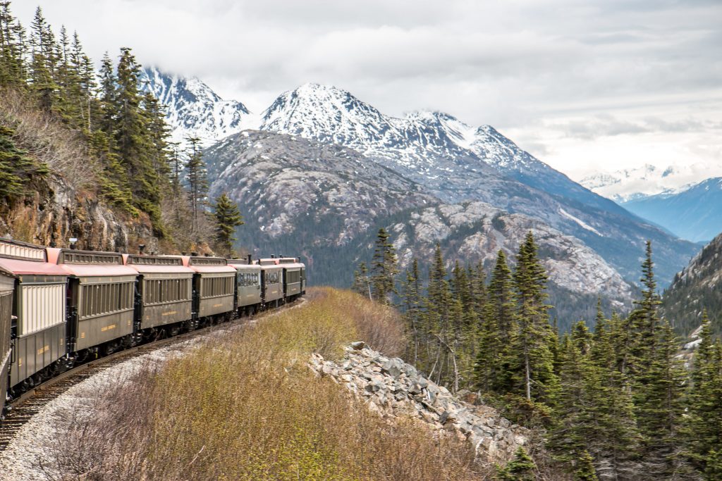
White Pass
Elevation 3,292 feet at Milepost S 14.3 South Klondike Highway.
White Pass was one of the two main routes of gold seekers on their way to Dawson City during the Klondike Gold Rush. The highway descends on a steep 11 percent grade into Skagway.
Eureka Summit
Elevation 3,322 feet at Milepost A 129.5 Glenn Highway.
The summit offers unobstructed views to south of the Chugach Mountains. Nelchina Glacier winds downward through a cleft in the mountains. To the northwest are the peaks of the Talkeetnas, and to the west the highway descends through river valleys which separate these two mountain ranges. This is the divide of three major river systems: Susitna, Matanuska and Copper.
Eagle Summit
Elevation 3,685 feet at Milepost F 107.3 Steese Highway.
Eagle Summit has a large parking area with 360 degree views. There’s a trailhead for Pinnell Mountain and in summer some of amazing wildflower viewing.
Maclaren Summit
Elevation 4,086 feet at Milepost P 36.7 Denali Highway.
From the top of Maclaren Summit drivers can view the Maclaren River valley and the Alaska Range to the west. To the east is Mount Hayes and Maclaren and Eureka glaciers.
Atigun Pass
Elevation 4,800 feet at Milepost J 244.7 Dalton Highway.
Atigun Pass crosses the continental divide and passes through tall mountains and avalanche terrain. The highway over the pass includes some steep grades of up to 12 percent.

Comments are closed.